Filipinos are being urged to prepare for heavy rains and turbulent weather next week. According to the latest updates from the Philippine Atmospheric, Geophysical and Astronomical Services Administration (PAGASA), the tropical cyclone internationally named “Bavi” has rapidly strengthened into a massive super typhoon as it moves steadily over the Pacific Ocean. While it is currently outside the Philippine Area of Responsibility (PAR), state meteorologists warn that it will bring significant weather changes to the country very soon.
Here is everything you need to know about its projected track, its local name, and how it will impact local weather conditions.
Read Also- Master the F Chord on Guitar: The Ultimate Guide for Filipino Beginners
When Will Tropical Cyclone Bavi Enter the Philippines?
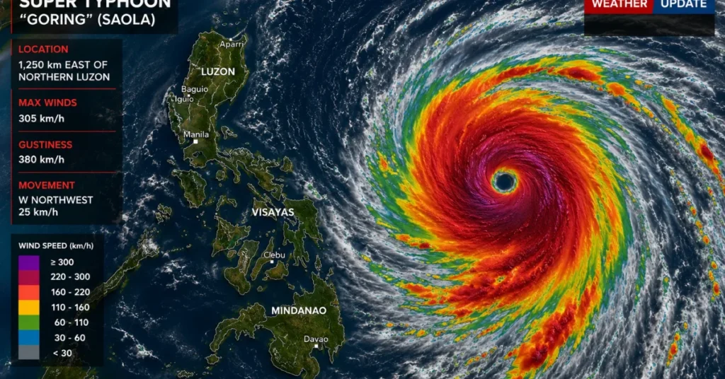
As of Friday evening, July 3, 2026, the eye of the super typhoon was located approximately 3,090 kilometers east of Eastern Visayas. It is packing maximum sustained winds of 185 kilometers per hour (kph) near the center, with violent gustiness reaching up to 230 kph.
Moving westward at a speed of 20 kph, PAGASA weather specialists noted that the weather disturbance is forecast to officially cross the PAR boundary by Tuesday or Wednesday next week (July 7 or 8).
Once it enters the monitoring domain, it will be assigned the local name Bagyong Inday, becoming the country’s ninth storm of the year.
Read Also- Mao Aplasca Ombudsman Decision: Ex-Senate Security Chief Sacked
The Threat of a Heavily Enhanced Habagat
Current forecast models suggest a high probability that the super typhoon will track near Northern Luzon. Because of this trajectory, PAGASA warns that Tropical Cyclone Wind Signals will likely be raised over large parts of Northern Luzon, and possibly extending into some areas of Central Luzon.
Even if the storm does not make direct landfall, its massive size and immense power will act as a vacuum, pulling in the Southwest Monsoon (Habagat). This monsoonal enhancement is expected to trigger widespread, heavy rainfall across large portions of Luzon and the Visayas starting Wednesday through Friday of next week.
With the combined effects of the enhanced Habagat and the approaching storm, local disaster risk reduction offices are advising the public to clear drainage systems, secure their homes, and continuously monitor official weather advisories, as forecast tracks can still shift.
Read Also- Philippine Passport Power: New Global Rankings and Visa-Free Destinations for Filipino Travelers